| Home |
| Early Life |
| Maps |
| Oregon Laws |
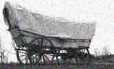
| The Trail |
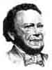
| Bush Biography |
| Tumwater Born |
| Thurston County |
| State History |
| Bush
Farm Today |
| FAQs |
| Timeline |
|
U.S.
National Park System - Cultural
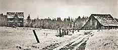
Landscape Project - 2003 Cowlitz Farm Cowlitz portage was the termination point of river travel from the Columbia, and the embarkation stage for the overland route north to Puget Sound. A large prairie was located about a mile from the landing, and from the mid-1830s on, cattle from Fort Vancouver were driven to the site to graze. In the summer of 1838, while Chief Factor McLoughlin was on furlough, James Douglas sent a herd of cattle to the Cowlitz from Fort Vancouver, with "Mr. Ross & eight men with a number of agricultural implements." Farming at the new establishment was already underway when Chief Factor McLoughlin returned to the Columbia from England in 1839, with the instructions to begin intensive farming operations at the Cowlitz, which the Hudson's Bay Company sold to the Puget's Sound Agricultural Company. Chief Trader John Tod had been sent to superintend establishment of the farm in the fall of 1838, and by the time McLoughlin arrived at the Cowlitz in November of 1839: "...[I] found that Mr. Chief Trader Tod had sown 275 bushels of Wheat, which looked as well as any I ever saw he had 200 acres of new land ploughed and which has been cross ploughed during the winter and 135 acres broken up and rails cut and carted to fence these fields." Hudson's Bay Company clerk John Work wrote a colleague, Edward Ermatinger, that fall: "Our friend Tod is superintending a newly established farm on an extensive scale at the Cowlitz..." The soil at Cowlitz was rich, and far better suited than that of Nisqually's for crop production. Over the years, the Cowlitz farm became the chief grain producer for the P.S.A.C. Land was rapidly put into production: by the spring of 1840, six hundred acres had been ploughed, and by the fall of 1841 one thousand acres were under cultivation. At the time of the 1846-47 inventory, 1,432 1/2 acres were under cultivation. Crops included wheat, oats, barley, peas, turnips, beans, cole seed and potatoes. During later testimony before the British and American Joint Commission, a former employee stated that in 1846 about twelve hundred acres were enclosed "...and subdivided by fences and ditches, into fields of convenient size, say from fifty to one hundred acres. Portions of this land were laid down under cultivated grasses, and the pastures were fully stocked." As stated, the Cowlitz Portage was the termination point of river travel from the Columbia, and the embarkation stage for the overland route to Puget Sound. The farm was established on Cowlitz Prairie, one of many prairies alternating with forests, located between the landing and Fort Nisqually to the north. The prairie was about a mile from the landing. Its size varied, according to who did the estimating: William Tolmie thought it was about four miles long and one mile wide; Duflot de Mofrás thought it was six by two miles, James Douglas said the plain "...contains a surface of about 3000 acres of clear land." The site, Douglas said in 1839, had the disadvantage of "...being separated from the River by a steep, rugged hill impracticable in its present state, to wheeled carriages: and the excavation of a convenient road, will be an enterprise attended with great labour and expense." Lieutenant Charles Wilkes, who arrived overland from the north in 1841 noted the farm was located on "an extensive prairie on the banks of that river [the Cowlitz]." He later reported:
Eugene Duflot de Mofrás, at Fort Vancouver the same year as Wilkes, described the Cowlitz River route:
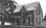
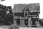
By the spring of 1840, some houses had been built, and by the spring of 1841, when Charles Wilkes visited the site, a dairy was in operation, and both a gristmill and sawmill were under construction. In 1845-46 a dwelling, granaries and outbuildings were erected at the mouth of the Cowlitz River to store the farm's produce until Company vessels could pick it up. The inventory of structures in 1846-47 listed a fifty by thirty foot dwelling house; a forty by one hundred foot store and two forty by thirty foot stores, two granaries and the sawmill "& improvements attached, incomplete." In addition, there were a number of outbuildings listed, including thirteen 105 by twenty foot barns, a "close bam," eighty by twenty-five feet, two piggeries, two stables, and six "men's houses." Two maps of "Cowelitz" Farm as cultivated in 1844-45, and 1845 and Spring 1846 shows the farm's organization to be compact, much more similar in nature to Nisqually's organization than to Fort Vancouver's, obviously due to the acreage available on its large plain. It was organized in a series of abutting rectangular and square fenced fields ranging in size from around nine to 105 acres. Some of the larger fields had the 105 by twenty foot barns, or grain sheds located within them. In the approximate center of the farm was a long rectangular enclosure in which were located two grain sheds and two barns in a line running southeast. Southeast of these were a cluster of buildings, which are not identified on the map, but must have been the dwelling house and possibly the store. Southeast of these, on the banks of a stream, were pigs styes--in 1846 the farm housed around three hundred hogs, excluding the young ones--and a stable, and three houses. Beyond the fenced enclosures, to the east on the plain, were several dwellings. The fields were numbered, and a comparison between the maps shows that crops were rotated within the different fields, although the fields ranging along the southeasterly edge of the farm appear to have been laid down permanently in timothy and clover. An employee later said the Company had "a comfortable, comodious dwelling house; a large two-story granary, with barns and sheds, conveniently distributed at various points over the farm." The lack of a road noted by Douglas in 1839, had been remedied by 1845: "They had a wagon road to the bank of the Cowlitz River, made at considerable cost," The sawmill was located near the Cowlitz River, and sheep--by 1846 about one thousand--were pastured on lands to the north of the farm; horses were pastured on the opposite bank of the Cowlitz.
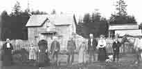
Cowlitz Farm
Declines In December of 1846, George Roberts, who had served as a Hudson's Bay Company clerk for a number of years at Fort Vancouver, was placed in charge of Cowlitz Farm by Chief Factor Peter Skene Ogden, succeeding Charles Forrest. At that time, production at the Cowlitz Farm was near its peak, with over fourteen hundred acres of land under cultivation, piggeries, stables, two large granaries, several store buildings, houses for the superintendent and employees, over a dozen barns, and an incomplete sawmill. The Puget's Sound Agricultural Company later claimed the Cowlitz Farm included 3,572 acres in total. As at Fort Vancouver, the 1849 gold rush took its toll on the labor force; by 1850-51, the number of employees at Cowlitz had been reduced from nineteen in 1847-48 to six. In 1851 Roberts resigned from the Company and was replaced by Henry Peers, another alumnus of Fort Vancouver. By this time, the bulk of the Cowlitz livestock had been transferred to Forts Nisqually and Victoria, and agricultural operations at the farm had been sharply reduced. In 1854, Isaac Stevens reported the the U.S. Department of State, that the Puget's Sound Agricultural Company claimed eight thousand acres of land at the Cowlitz, although, he said, "According to plat deposited at Surveyor General's office, their tract contains only about three thousand acres. Some years back about fifteen hundred acres of land were under cultivation, but of late years the cultivation of land has been almost entirely abandoned. The fences have been allowed to go to decay; much of the hay even has not been cut." According to his agent, Isaac Ebey, "The buildings are becoming old and dilapidated." Until 1856, minor operations of the company continued to be conducted at the farm, although encroachments by Americans had significantly reduced its holdings. In 1859, Roberts made arrangements to occupy the remaining Cowlitz Farm lands and buildings for the Puget's Sound Agricultural Company to maintain its claim to the property until settlement of the company's claim with the United States; his obligation was to keep the buildings in good repair. From that time until 1871, when Roberts left for Cathlamet, Washington, he was embroiled in a number of disputes with Americans who refused to recognize the company's claims to the land. The granaries built at the mouth of the Cowlitz were, by 1854 in poor condition. In 1857, according to Dugald Mactavish, the buildings--but not the land--were sold to an American.
|